How did this rock get here? 🪨
Some rocks have travelled hundreds of miles. But how does a rock weighing thousands of tons go anywhere at all?
One rock. The wrong place. And a question that helped us discover a world covered in ice.
You are walking through a forest, across a field or along a mountain trail when you notice a boulder.
Perhaps it is enormous.
Perhaps it is simply different.
Different colour. Different texture. Different minerals.
You look at the ground beneath it.
Then at the surrounding cliffs.
And something doesn't quite fit.
This rock doesn't seem to belong here.
That small observation has puzzled people for centuries.
Today, geologists have a name for rocks like these: glacial erratics. They are pieces of rock transported by moving ice and eventually deposited somewhere geologically different from the place where they originated.
Some travelled only a few kilometres.
Others travelled hundreds.
Some are small enough to hold in your hand. Others weigh thousands of tonnes.
And scattered across landscapes from Britain to Canada and New Zealand, they have helped scientists reconstruct something extraordinary:
landscapes that no longer exist.
What makes a rock an erratic?
It isn't size.
The word comes from the Latin errare, to wander.
What makes an erratic interesting is that it has wandered away from the geology it belongs to.
Imagine finding granite sitting on limestone.
Or quartzite on a prairie hundreds of kilometres from the mountain formation where that particular quartzite occurs.
The rock itself may not look particularly mysterious.
Its location is the mystery.
Glaciers are remarkably effective transport systems. Moving ice can incorporate rocks falling onto its surface, pluck material from the bed beneath it, and trap debris along its sides or within the ice.
Some rocks travel near the glacier's base, where grinding and abrasion may scratch, polish, fracture or round them. Others can ride higher in or on the ice and arrive surprisingly little altered.
Eventually the ice melts.
Its passenger stays.
Sometimes almost delicately.
Sometimes in a place that looks completely absurd.
So... how did everyone think these rocks got here?
Before we follow the ice, forget for a moment that you already know the answer.
Imagine standing beside an enormous boulder two hundred years ago.
You recognise the rock.
You know that rocks like it occur far away.
But there is no glacier anywhere nearby.
How would you explain it?
That was a serious scientific problem.
Huge floods were proposed. Violent currents might have swept boulders across the landscape. Earthquakes, rising mountains, volcanoes and other catastrophic events were invoked to explain deposits that seemed impossible to reconcile with the landscapes people could see around them.
Then came an especially clever possibility:
floating ice.
Charles Lyell argued in the nineteenth century that floating ice could transport boulders across seas and release them when it melted.
It wasn't a foolish idea.
Icebergs really can carry rocks.
And for geologists trying to explain scattered boulders without imagining enormous glaciers covering landscapes where no glaciers existed anymore, floating ice provided a plausible vehicle. The idea remained influential in British geology even after a terrestrial glacial explanation had been proposed.
The observations were real.
The travelling rocks were real.
The mystery was the vehicle.
And there is something wonderful about this part of the story.
Nobody could rewind the landscape and watch the boulder travel.
They had to learn to read the clues.
And then someone began to follow the rock.
Instead of asking only:
What force could move something this large?
another question becomes possible:
Where have I seen this rock before?
That changes everything.
A rock carries something rather like a geological fingerprint.
Its minerals, texture, chemistry and structure can connect it to a particular geological formation. In geologically varied mountains, some rock types can even point towards individual valleys or source regions.
The Alps provided an extraordinary natural laboratory for this.
Granite boulders of Alpine origin lie scattered across the predominantly limestone Jura. Researchers realised that different crystalline erratics could be traced towards different parts of the Alps. Modern work on the former Valais Glacier still uses these lithological fingerprints: some erratic types can be connected with the Mont Blanc massif, others with the southern valleys of Valais or the Aar Massif.
Britain gives us another beautiful example.
Follow the Shap granite
Shap granite comes from a relatively small intrusion in Cumbria, only about 8 km² in outcrop. It is particularly recognisable because it contains conspicuous large potassium-feldspar crystals.
Find pieces of that distinctive rock elsewhere and you have a clue.
Map enough of them and the clues begin to form a pattern.
The rock becomes a tracer.
Not because it points like a compass.
Because we know where it started.
Now imagine doing that with hundreds of erratics.
The stones begin to make a trail.
And suddenly the question is no longer only:
How did this rock get here?
It becomes:
What must the landscape have looked like for this rock to get here?
Who first followed the rocks?
There isn't a neat answer involving one scientist having one brilliant idea on one particular morning.
The history is far more interesting.
As early as 1723, Swiss naturalist Johann Jakob Scheuchzer recognised that glaciers were capable of transporting large stones. Later, Scottish thinkers James Hutton and John Playfair connected glaciers with erratic boulders and former expanded Alpine ice. Historical work has described Playfair's 1802 explanation as the first valid published account of wandering boulders being carried far from their source by glaciers, although Playfair himself was developing ideas associated with Hutton.
And then an extraordinary observer enters the story.
Jean-Pierre Perraudin
Perraudin wasn't a famous professor.
He was a farmer and mountain observer from the Val de Bagnes in Switzerland.
He noticed enormous blocks on the valley sides.
He noticed marks left on rock surfaces.
And around 1815, he proposed something startling: the glaciers visible in the mountains must once have extended much farther down the valley.
He tried to persuade geologist Jean de Charpentier.
Charpentier was sceptical.
Engineer Ignaz Venetz then gathered evidence for a much greater former extent of Alpine glaciers and presented his ideas in the 1820s. Charpentier eventually changed his mind and became a strong advocate of the glacial explanation.
And Charpentier, in turn, helped convince Louis Agassiz.
Agassiz pushed the idea onto a much larger stage. In 1837 he publicly presented a theory of extensive former glaciation at Neuchâtel. His Études sur les glaciers appeared in 1840, followed by Charpentier's major work in 1841. Agassiz then compared Alpine evidence with landscapes elsewhere, including Britain.
So perhaps this story shouldn't be remembered as:
one man discovered the Ice Age.
It is more interesting than that.
Someone noticed.
Someone proposed.
Someone doubted.
Someone looked again.
Someone collected more evidence.
Someone changed their mind.
And the wandering rocks kept sitting there while humans argued about them.
When two worlds of ice met
Now travel to Alberta, Canada.
On an open prairie southwest of Okotoks sits something difficult to overlook.
Big Rock.
The Okotoks Erratic is approximately 41 metres long, 18 metres wide and 9 metres high and weighs an estimated 16,500 tonnes. It is quartzite from a geological formation whose source lies in the Rocky Mountains near what is now Jasper National Park.
But Big Rock isn't really a story about one enormous boulder.
Look south and north.
There are more.
And more.
Big Rock belongs to the Foothills Erratics Train, a narrow trail of distinctive Rocky Mountain quartzite blocks stretching for more than 580 kilometres along the eastern foothills, from the Jasper region towards northern Montana.
Why should rocks from one part of the Rockies end up forming such an extraordinary line?
Because two enormous systems of ice met here.
Glaciers flowing out from the Rocky Mountains carried mountain debris eastward. At the same time, the immense Laurentide Ice Sheet expanded westwards across the continental interior.
Eventually the mountain ice and continental ice coalesced along the Rocky Mountain front.
The ice coming from the mountains could no longer simply continue eastward.
Its flow was deflected.
And the rocks travelled with it.
At the Hetherington Erratics Field, Alberta's heritage interpretation describes the mountain glacier as initially moving eastward before being deflected south by the Laurentide Ice Sheet. There the erratics train even narrows dramatically, from several kilometres across to roughly one kilometre.
So that extraordinary trail of quartzite is not random geological litter.
Its distribution preserves evidence of the interaction between two immense bodies of ice. The Alberta Geological Survey identifies the train as a feature whose distribution may relate to the coalescence of the Laurentide and Cordilleran ice systems.
And modern dating has added another chapter.
Researchers have measured cosmogenic beryllium-10 in Foothills erratics. A 2019 study placed the detachment of the western Laurentide margin from the Rocky Mountain ice at approximately 14,900 ± 900 years ago. Intriguingly, ages measured over about 500 kilometres showed no clear north-south progression, consistent with a relatively rapid opening of a long wedge of ice-free terrain between the retreating ice masses.
The erratics therefore record more than where ice once travelled.
They help researchers investigate where great ice masses met, and when they pulled apart again.
How can you put a date on a wandering rock?
This sounds almost impossible.
A boulder doesn't arrive with a luggage tag saying:
Dropped here 15,000 years ago.
But its exposed surface can contain another kind of clock.
When a rock surface is exposed to the sky, high-energy cosmic rays interact with minerals in the rock and produce rare cosmogenic nuclides, including beryllium-10, aluminium-26 and chlorine-36.
Measure how much has accumulated, account for factors such as altitude, erosion and previous exposure, and researchers can estimate how long that surface has been exposed.
The technique is called cosmogenic surface-exposure dating and is widely used to constrain the timing of former glaciations.
It isn't a perfect stopwatch. A rock may have been exposed before transport, buried again, eroded, shielded by ice or snow, or inherited cosmogenic nuclides from an earlier episode. Studies of Scottish erratics, for example, show why those complications have to be modelled carefully.
But think about the transformation in our investigation.
The first observers asked:
Where did this rock come from?
Now we can also ask:
How long has this surface been exposed to the sky?
A boulder balanced on the edge
Across North America, in Maine's Acadia National Park, another erratic tells the story on a much smaller scale.
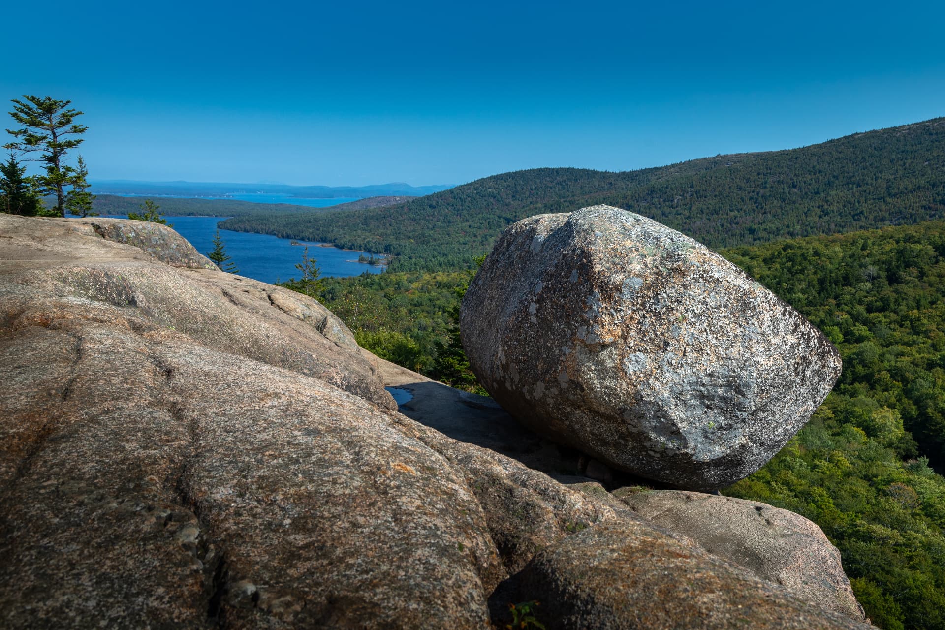
Bubble Rock sits improbably near the edge of South Bubble Mountain.
Look beneath your feet.
The mountain is made of Cadillac Mountain Granite.
Now look at Bubble Rock.
It isn't.
Bubble Rock is Lucerne Granite, a rock found about 30 miles to the northwest. The National Park Service actually invites visitors to compare the two, looking at differences in colour and crystal size.
This is the geological fingerprint happening in front of you.
Look at the boulder.
Look at the mountain.
They don't match.
Now go looking for where the boulder does.
When a rock protects the ground beneath it
Cross the Atlantic to the Yorkshire Dales.
At Norber, near Austwick, large blocks of older rock lie scattered across younger limestone.
Some appear to stand on little limestone pedestals.
The glacier brought the boulders into the landscape. Afterwards, rainwater gradually dissolved the exposed limestone around them. Where a boulder protected the limestone beneath it, weathering proceeded differently.
The result is wonderfully odd.
The erratic has become part of the experiment.
It doesn't only tell us something about the vanished ice.
It has been changing what happens beneath it ever since.
The rock survived. The ice didn't.
Now cross into the Southern Hemisphere.
Near Lake Pukaki in New Zealand's South Island, the Department of Conservation maintains a tiny trail to a group of glacial erratics.
The Pukaki Boulders Track is only 200 metres one way, roughly a ten-minute walk. The boulders were deposited by the huge glacier that dominated this landscape more than 12,000 years ago.
Stand beside one.
Then stop looking at the boulder.
Look around.
Because the erratic is only one surviving piece of a much larger vanished landscape.
The rock survived. The ice didn't.
But the ice did not disappear without leaving evidence everywhere.
Nearby, another short trail crosses moraine hummocks, piles and ridges of debris associated with former ice, and circles a distinct kettle hole.
A kettle hole forms when a block of glacier ice becomes stranded or buried in sediment and eventually melts, leaving a depression in the landscape. At Pukaki, you can walk around one.
Elsewhere around the Mackenzie Basin, glacial deposits, moraines and outwash record different parts of the same story.
And this is where an erratic teaches us perhaps its most useful lesson.
Don't stop at the rock.
Once you know ice was here, look for the rest of the landscape.
A ridge might be a moraine.
A hollow might mark vanished ice.
A broad valley may have been reshaped by a glacier.
A chain of misplaced rocks may record the direction in which ice once moved.
The boulder isn't the whole story.
It is the clue that teaches you how to start reading it.
Can you find an Ice Age in a city?
You don't necessarily need mountains.
In Birmingham, England, glacial erratics are among the surviving traces of the city's glacial past.
On the University of Birmingham campus, the Aston Webb Boulder sits only about 200 metres from the Lapworth Museum of Geology. It was discovered in 1909 and today has an interpretation panel.
Even better, Birmingham's Erratics Project has created eight routes for people to go looking for glacial boulders around the city.
An Ice Age treasure hunt hiding among streets, parks and buildings.
Calgary offers another.
In West Nose Creek Park, you can find Split Rock, one of the city's best-known erratics. Its rock has been traced back towards the Mount Edith Cavell area near Jasper.
The rock travelled out of the mountains with the ice.
Much later, freeze-thaw weathering split it.
Bison probably rubbed against it.
Now people walk past it in a city park.
One rock.
Several landscapes.
Several histories.
GO FIND ONE 🪨
You don't have to cross an ice sheet.
The rock already did.
Here are a few places where you can investigate the evidence yourself.
🇨🇦 Okotoks Erratic · Alberta, Canada
Meet Big Rock on the prairie and then imagine it as one point in a 580-kilometre trail of Rocky Mountain quartzite. The site has longstanding cultural and ceremonial significance for Blackfoot peoples and contains protected pictographs, so visitors are asked to stay off the rock.
🇨🇦 Split Rock · Calgary, Alberta, Canada
An urban erratic in West Nose Creek Park. Look at the rock, then consider just how far its geological home lies from this city park.
Explore West Nose Creek Park →
🇺🇸 Bubble Rock · Acadia National Park, Maine, USA
Walk up South Bubble and compare Lucerne Granite with the Cadillac Mountain Granite beneath your feet. The National Park Service has turned precisely that comparison into an EarthCache investigation.
🇺🇸 Ice Age National Scenic Trail · Wisconsin, USA
For the next step beyond one boulder: a 1,200-mile trail through a landscape containing moraines, kettles, eskers, drumlins and erratics left by continental ice.
Explore the Ice Age National Scenic Trail →
🇺🇸 Three Maidens · Pipestone National Monument, Minnesota, USA
Large glacial erratics that are also culturally and spiritually significant to Indigenous peoples. This is a place for observation and respect rather than climbing.
🇬🇧 Norber Erratics · Yorkshire Dales, England
Walk among scattered erratics and look for the extraordinary limestone pedestals beneath some of them.
🇬🇧 Birmingham Erratics · Birmingham, England
See the Aston Webb Boulder beside the university, visit the Lapworth Museum, or choose one of the city's erratics trails. An excellent place to discover that evidence of an Ice Age can survive inside a modern city.
Discover Birmingham's erratics →
🇳🇿 Pukaki Boulders Track · Canterbury, New Zealand
A wonderfully small expedition: 200 metres, around ten minutes one way, to boulders deposited by the former glacier.
Walk the Pukaki Boulders Track →
🇳🇿 Pukaki Kettle Hole Track · Canterbury, New Zealand
Once you've seen the boulders, widen the investigation. This easy 4-kilometre walk passes through moraine hummocks and circles a kettle hole formed by melting glacial ice.
Walk the Pukaki Kettle Hole Track →
🇳🇿 Tasman River Track · Canterbury, New Zealand
For a longer exploration, follow the Tasman River through a glacial landscape where large erratics sit beneath the Southern Alps / Kā Tiritiri o Te Moana.
Explore the Tasman River Track →
YOUR FIELD JOURNAL
Next time you find a solitary boulder, don't begin by asking how old it is.
Begin with its surroundings.
Does this rock look like the bedrock around it?
Look at colour.
Crystal size.
Texture.
Layers.
Veins.
Rounded or angular edges.
Then widen your view.
Where is the nearest exposed rock that looks similar?
Could the boulder simply have fallen from somewhere above you?
Is there evidence of former ice nearby?
Look for a U-shaped valley, polished or scratched bedrock, ridges that might be moraines, unusual hollows, glacial sediments or other rocks that seem equally out of place.
And perhaps the most interesting question:
Where have I seen this rock before?
You may not be able to identify it.
That's fine.
The first people who puzzled over erratics didn't immediately know the answer either.
They started by noticing that something didn't fit.
EXPLORER CHALLENGE
Follow a wandering rock
Choose one glacial erratic near you, or visit one of the places above.
Don't begin by reading its interpretation panel.
Look first.
What is the rock made of?
Does it match its surroundings?
What clues suggest that it arrived from somewhere else?
Which direction would you search for its geological home?
Then look beyond the rock.
Can you find another clue left by ice?
Only afterwards, read the geological explanation.
See how close your questions came to the questions geologists once asked.
Because a glacial erratic is more than a rock carried by ice.
It is an invitation to reconstruct a journey you cannot see.
And sometimes, if you follow one misplaced stone far enough, you discover an entire vanished world.
SOURCES & FURTHER EXPLORATION
Scientific sources
Hansen, B. (1970).
The Early History of Glacial Theory in British Geology.
Journal of Glaciology, 9(55), 135–141.
DOI: 10.3189/S0022143000026861
A fascinating reconstruction of the debate between floods, marine currents, floating ice and terrestrial glaciers, and of the reception of Agassiz's glacial theory in Britain.
Seylaz, L. (1962).
Early Discoverers XV: A Forgotten Pioneer of the Glacial Theory: John Playfair (1748–1819).
Journal of Glaciology, 4(31), 124–126.
DOI: 10.3189/S002214300001827X
On Playfair's remarkably early explanation of Alpine glaciation and wandering boulders.
Davies, G. L. (1968).
Early Discoverers XXVI: Another Forgotten Pioneer of the Glacial Theory: James Hutton (1726–97).
Journal of Glaciology, 7(49), 115–116.
DOI: 10.3189/S0022143000020451
Adds an important wrinkle to the “who was first?” question: Playfair published the idea clearly, but was developing an explanation already proposed by Hutton.
Jouvet, G., Seguinot, J., Ivy-Ochs, S. & Funk, M. (2017).
Modelling the diversion of erratic boulders by the Valais Glacier during the Last Glacial Maximum.
Journal of Glaciology, 63(239), 487–498.
DOI: 10.1017/jog.2017.7
Uses the origins and distribution of characteristic Alpine rocks together with ice-flow modelling to reconstruct the journey of erratic boulders carried by the former Valais Glacier.
Jackson, L. E. Jr., Phillips, F. M., Shimamura, K. & Little, E. C. (1997).
Cosmogenic 36Cl dating of the Foothills erratics train, Alberta, Canada.
Geology, 25(3), 195–198.
DOI: 10.1130/0091-7613(1997)025<0195:CCDOTF>2.3.CO;2
A key study of the Foothills Erratics Train and the interaction between Rocky Mountain glaciers and the Laurentide Ice Sheet.
Margold, M., Gosse, J. C., Hidy, A. J., Woywitka, R. J., Young, J. M. & Froese, D. (2019).
Beryllium-10 dating of the Foothills Erratics Train in Alberta, Canada, indicates detachment of the Laurentide Ice Sheet from the Rocky Mountains at ~15 ka.
Quaternary Research, 92(2), 469–482.
DOI: 10.1017/qua.2019.10
Uses cosmogenic ¹⁰Be to investigate when the Laurentide Ice Sheet separated from the Rocky Mountain ice masses.
Places to explore
Big Rock · Okotoks, Alberta, Canada
Official Government of Alberta information about the erratic, its geological history and its cultural significance to Blackfoot peoples.
Split Rock · Calgary, Alberta, Canada
City of Calgary information for West Nose Creek Park and its glacial erratic.
Explore West Nose Creek Park →
Bubble Rock · Acadia National Park, Maine, USA
National Park Service EarthCache investigation comparing Bubble Rock with the bedrock beneath it.
Ice Age National Scenic Trail · Wisconsin, USA
National Park Service visitor information for exploring one of North America's great glacial landscapes.
Three Maidens · Pipestone National Monument, Minnesota, USA
National Park Service information about the glacial boulders and their cultural significance.
Norber Erratics · Yorkshire Dales, England
Yorkshire Dales National Park information for exploring the Norber and Ingleborough landscape.
Aston Webb Boulder & Birmingham Erratics · Birmingham, England
University of Birmingham information about the Aston Webb Boulder and Birmingham's erratic trails.
Discover Birmingham's erratics →
Pukaki Boulders Track · Canterbury, New Zealand
New Zealand Department of Conservation information for the short walk to the glacial boulders.
Walk the Pukaki Boulders Track →
Pukaki Kettle Hole Track · Canterbury, New Zealand
New Zealand Department of Conservation information for exploring moraine hummocks and a glacial kettle hole.
Walk the Pukaki Kettle Hole Track →
Tasman River Track · Canterbury, New Zealand
New Zealand Department of Conservation information for a longer exploration of erratics and the Southern Alps glacial landscape.
Explore the Tasman River Track →
ABOUT THE TITLE IMAGE
Bubble Rock · Acadia National Park, Maine, USA
A glacial erratic perched on South Bubble, overlooking the forest and lakes of Mount Desert Island.
Photo attribution:
Christian Collins.jpg) · CC BY-SA 2.0 · via Wikimedia Commons